Once the Dredging & Reclamation module is enabled, you will see an extra ribbon tab as shown below. For a description of how to enable the Dredging & Reclamation module see Activating Licenses.
The following tools are available in the dredging and reclamation tab:
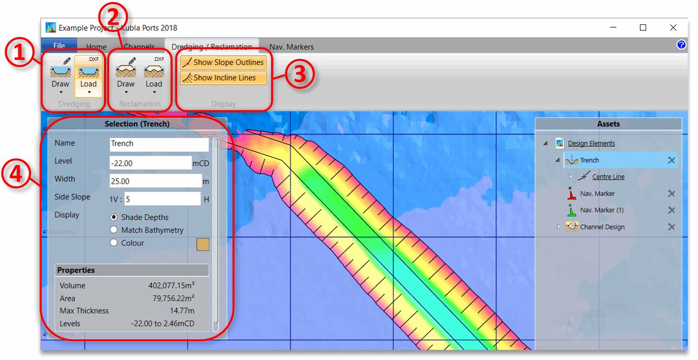
- ① Here you can add dredging, either as areas defined by an outline, or trenches defined by a centre-line and width. For both options you can either draw the definition line on the screen or load it from a CAD .dxf file. By default, it will add the previous option (area or trench) that you have added. You can change this by clicking on the bottom of the split button.
- ② Here you can add reclamation, either as areas defined by an outline, or berms defined by a centre-line and width. For both options you can either draw the definition line on the screen or load it from a CAD .dxf file. By default, it will add the previous option (area or berm) that you have added. You can change this by clicking on the bottom of the split button.
- ③ Here you can adjust how the dredging and/or reclamation lines are displayed on the screen.
- ④ When you have drawn and selected a dredging or reclamation item, it's properties can be edited here.
Once the centre-line or outline has been defined dredging or reclamation item will be created and will appear in the side bar. This item will have the following automatically-generated child item:
- Centre Line or Outline. If you need to edit this definition line, you can select this from the panel when in Design View and the line will appear on the screen. You can then either drag the points of the line around on the screen, or you can select points and type in their exact co-ordinates. If you need to split an edge of the line you can select the edge and click on 'Split Edge'.
The item itself will have the following properties:
- Name The name of the dredging or reclamation.
- Level The level of the dredging or reclamation.
- Width (trenches and berms only) The width of the trench or berm.
- Side Slope The angle of the side slopes for the dredging or reclamation.
- Display How the dredging or reclamation is to be shaded. Either shade by depth, shade levels as for the bathymetry, or shade in a specified colour.
The dredging or reclamation item can generate the following exports:
- Quantity Summary (.docx, .pdf). Exports a summary of the quantities that have been calculated, such as volumes, areas and depths.
For dredging and reclamation areas, it is possible to set the batter angle for individual edges of the outline. This is done by selecting the edge in the side panel and adjusting the batter angle for the edge which will be displayed in the selection panel.